Class IV Cumberland River, KY
Below the Falls (Cumberland Falls to Pulaski River Confluence)
As the Cumberland River flowed off the Cumberland Escarpment just upstream of Burnside, when the Earth was much younger, it made a spectacular waterfall. Over time, the mighty Cumberland’s flow cut back under the edge of the resistant sandstone of the escarpment until the rock wore too thin and collapsed into the river bed below it, creating a new falls.
The Cumberland River continued to chew its way upstream over thousands of years by this process, leaving behind a jagged, deep and incredibly scenic river valley that now makes one of the best whitewater floats in the upper South.
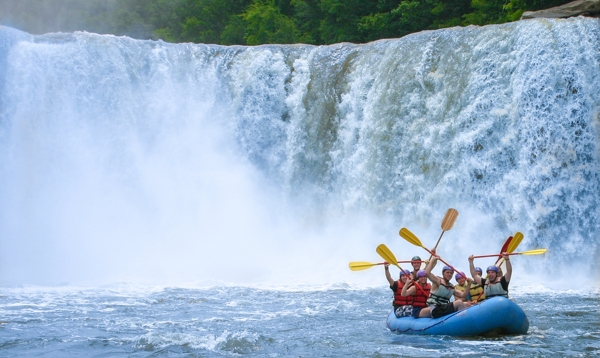
At the head of this valley lies world-renowned Cumberland Falls, one of the largest waterfalls east of the Mississippi River. The Cumberland River falls off massive ledges of ancient sandstone to the river 68 feet below and during late winter and spring’s high flows and 55 feet below in the low water of summer and fall. Moonbeams reflect in the mists rising from the falls generate moonbows during bright moon periods of clear skies.
The building-sized boulders that line the riverbed and shore are the debris left by the headward erosion of the mighty Cumberland Falls. The pristine nature of the 16.1 mile section of the river from Summer Shoals, downstream to the headwaters of Lake Cumberland, compelled the Kentucky legislature to designate this stretch as a Kentucky Wild River. (KYFWR)
Section Details
| Trip Length | Full Day, 15.7 Miles |
| Fishing | Yes |
| Camping | Yes |
| Manager | State, Kentucky Department of Fish & Wildlife Resources |
| Wild & Scenic | No |
| Water Trail | Yes |
| Partner Information |
http://fw.ky.gov/Education/Pages/Cumberland-River-below-the-Falls.aspx
https://fw.ky.gov/Education/Pages/Blue-Water-Trails.aspx |